The 17 August Izmit earthquake, Mw=7.4, 3.02 AM local time, killed more than 15,000 people and left hundreds of thousands homeless as a result of extensive damage to buildings. We ( Dr.Yutaka Nakamura (President of SDR ), Dr. Dilek Gurler (Research Engineer ), Mr.Tsutomu Sato ( M.Sc.,Research Engineer )) left Tokyo at 31st of August in the morning and arrived Istanbul at the same day evening. Our purpose was two fold including the damage investigation and effect of earthquake to the historical buildings ( Hagia Sophia Museum, Suleymaniye Mosque etc.) in Istanbul.
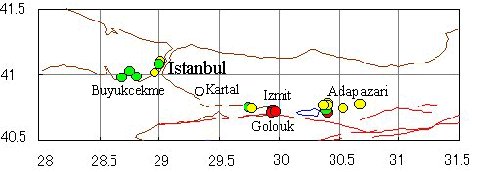
Places we were visited
Tectonics:
Earthquake occurred on the North Anatolian fault zone. Strong ground motion caused damage in the area of 40 x 200 km centered as Izmit, Golcuk, Yalova and Adapazari.
Turkey is bounded on the east by the East Anatolian Fault zone, on the north by the North Anatolian Fault zone, on the west by a diffuse zone surrounding the Agean region, and on the south by Cyprus arcs. Arabian plate pushes the small Turkish microplate westwards, causes earthquakes on the NAF. Izmit-Adapazari region has large earthquakes in its past also. During August 17, earthquakes, surface rupture is observed around 125 km, and average displacement along the surface is 2.5m, right lateral strike slip.
Izmit is placed on the north of north Amatolian fault and contains basins and rivers. Surface layers generally consists of very thick soft clay or loose sand layers which causes high damage potential with high seismic activity.
Earthquake Photos:
On September 5th, we went to Izmit and Adapazari and observed some surface signs of the fault as well as damage in and around the vicnity of these areas. When we moved through TEM, collapsed parts have already been cleaned up. A geologist friend Mr.Mujdat Ozkaya ( M.Sc ) gave us his guidance to see surface ruptures. Following pictures starts Izmit gulf, showing surface ruptures and damage and continues to Adapazari. Earthquake destroyed some parts of Adapazari completely, whole city was intensely and extensively damaged by both the effects of liquefaction and strong acceleration. We took microtremor records on the liquefied area of the city and some strong motion observation points of Kandilli observatory and earthquake Research Institute. These points are shown in above map. Collapsed buildings are mainly 6-8 story reinforced concrete frame buildings. Inadequate soil condition and liquefaction seemed played an important role on structural damage. Reinforced concrete frame buildings in Turkey suffer from earthquakes because of design, application and material problems. Most of the buildings are designed without following earthquake resistant design code. Poor concrete quality, poor reinforcement, soft story, poor quality of soil in construction site can be given as a technical cause damage in most of the buildings.
Research on Historical Buildings:
In June 1999, we had chance to do microtremor measurements on some historical spots. Hagia Sophia Museum and Suleymaniye were two of them. Apart from the damage investigation on our visit this time, we repeated these measurements to see if threr is any effect of earthquakes to these monuments. Analysis are still in process and soon we will make them available in this page.